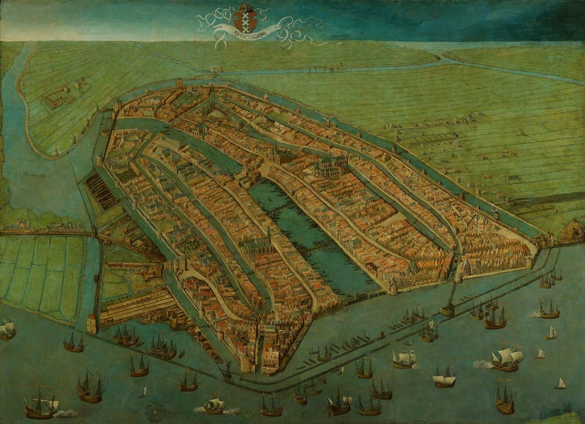

Bird's eye view of Amsterdam, 1538
Cornelis Anthonisz.
Oldest surviving map of Amsterdam, showing the city's finished medieval walls, towers and gates. As with most old maps of Amsterdam the city is shown from the IJ, so that the view is directed to the south rather than the north.
(https://en.wikipedia.org/wiki/Cornelis_Anthonisz.#/media/File:View_of_Amsterdam.JPG)
This is way before the concentric canals were built.
Amsterdam is shown as a walled city, situated in a waterlogged area at the mouth of the river Amstel. Churches, convents and city gates are the most striking buildings in the city which, in 1538, had a population of about 12,000. Cargo vessels dropped anchor outside the palisade in the IJ. The goods were then loaded onto lighters, which transported them along the Damrak to the centre of the city. On the Dam the goods were weighed and traded. Many boats were needed for Amsterdam’s carrying trade. On the left, outside the canal encircling the city, we can see shipyards, roperies, and saw-mills.
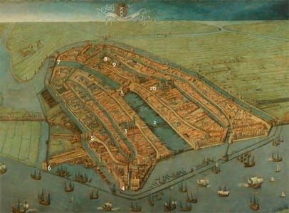
[Numbers refer to those in added view]
1. Dam or Dam Square
2. Damrak is now only open till #2 seen from this side, the rest is built over by the Exchange of Berlage, Beursplein and the Bijenkorf department store.
3. Oude Kerk or Old Church
4. Schreierstoren
5. St. Anthoniespoort [former city gate] St Anthony’s Gate was one of Amsterdam’s three main gates. The others were Reguliers gate, the bottom of which forms the base of Mint Tower, and the old Haarlemmer Port, which no longer exists. In 1601 the city walls were torn down to allow Amsterdam to expand further. St Anthony’s Gate remained standing, although it was now redundant. On either side, part of the canals were filled in to create a square: St Anthony’s Market – since renamed Nieuwmarkt. In 1617 the former city gate was provided with a new function: that of weigh house. Some of the arrow loops were widened to form windows, giving the building a more open character. Amsterdam’s merchants were pleased with the new weigh house, since the old building on Dam Square had been unable to handle the explosive growth of trade.
6. Montelbaanstoren
7. Munttoren – Mint Tower
8. Begijnhof
9. Amsterdam Orphanage – now Amsterdam Historical Museum
10. Nieuwe Kerk – New Church on Dam Square
The palisade in the IJ closest to you is now filled in with Amsterdam Central Station.
(https://tippinthescales.wordpress.com/2010/06/19/earliest-map-of-amsterdam-1538/)
46 x 63 in
Uploaded on by Suzan Hamer
Cornelis Anthonisz.
artistArthur
Wait what?


